| Author |
 Topic Topic  |
|
Stanley
Local Historian & Old Fart


36804 Posts

|
|
 Posted -
16/03/2009
:
07:21 Posted -
16/03/2009
:
07:21
|
The place to tell us about your favourite walks and tall tales about rambling.
Stanley Challenger Graham

Barlick View
stanley at barnoldswick.freeserve.co.uk
|
|
| Replies |
| Author |
|
|
panbiker
|
Posted - 30/11/2010 : 22:59
Gus the graveyard was swept for ancestors many years ago when we first started resarching the family tree. The stones are very weatherbeaten and most are not readable. That was the last time I was in Stalling Busk before our visit last weekend that was back in the 1980's.
Ian  |
gus
|
Posted - 30/11/2010 : 23:15
This ruin is all that remains of the original Parish Church at Stalling Busk. It dates from around 1722, although some of the structure incorporates stonework from an earlier church on the site dating from 1602 - 1603. The interior of the church is divided by two arcades which run north-south rather than follow the usual plan of east-west alignment. These arcades probably date from the early nineteenth century.
The church was still in use in the early twentieth century, but it was in a poor state of repair. When the new church of St. Mathews was built in the village of Stalling Busk in 1908-09, the Old Church fell into disuse and was soon stripped of its roof and furnishings.
Some consolidation work was carried out in 1981, when the alter was also rebuilt in its present position against the north wall rather than in its original position in the east aisle.
Further restoration was then undertaken in 2000.
In its early years this building was a chapel of ease. Stalling Busk became a perpetual curacy in the 1750s and a fully independent ecclesiastical parish in the 1860s.
The parish covers the whole of Raydaleside, and about 750 people from this area lie buried in the churchyard. 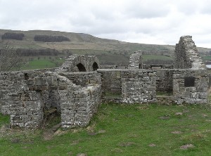
Gus
http://www.flickr.com/photos/angusbrennan/
|
wendyf
|
Posted - 01/12/2010 : 09:48
Sounds like a wonderful weekend Ian, walking, good food and family history! Glad you both escaped serious injury when you fell. I remember my sister in law breaking her ankle by slipping on a patch of ice coming down Cross Fell on a family Boxing Day outing, just as dusk was falling. Not Nice.
|
gus
|
Posted - 01/12/2010 : 12:21
I fell twice on Tuesday on my Conistone walk Ian, The first thing Robin, my lad asked "is the camera o/k " this, as i was laid face first in a foot of snow, fortunate that the snow was so deep otherwise i could have done some damge... needless to say i left an excellent imprint in the snow, it looked like a Helipad when i was upright .....lol.
Gus
http://www.flickr.com/photos/angusbrennan/
|
Another
Traycle Mine Overseer

6250 Posts

|
|
Posted - 01/12/2010 : 12:30
Nice pics and description Ian. Thanks for your trouble. Nolic
" I'm a self made man who worships his creator"  |
Callunna
Revolving Grey Blob


3044 Posts

|
|
Posted - 01/12/2010 : 17:47
I'd never heard of Stalling Busk - sounds and looks fascinating.
Gus - you didn't say whether the camera was, in fact, OK...
Just while I'm on, our Barlick walks book is apparently, and I quote, "selling like hotcakes" at the Council Shop. They've just ordered more copies (now over 50 in total) because "they're flying off the shelf".
They can also be ordered off www.bernulf.com via PayPal.
|
panbiker
|
Posted - 01/12/2010 : 20:25
quote:
gus wrote:
We were all wondering how they managed to get the dearly departed to the graveyard as there was no obvious road in or out.
I forgot to comment on this Gus. There are two paths to the old church. One from Stalling Busk and another that branches from the track roughly half way between Stalling Busk and Marsett. I would assume that in such small communities that it would not be uncommon to carry the deceased from either hamlet to the church and graveyard. You are correct about some of my relatives being buried there. I have just found a burial record for one of Johns children who indeed was buried at that site. I feel fairly sure that that it will be the final resting place for many more, just not found the proof yet. I said previously, we visited many years ago to search for graves but most of the headstones are very worn and undecipherable. I need to increase our subs to Ancestry to get at the parish and probate records. All the information we have for this generation of the family has been gleaned from material seen at record offices when we first started searching our roots which was the only way to do it then.
Heather, both Stalling Busk and Marsett are quite remote, there is no link between the two apart from the old track. If you want to drive to either you have to go either side of Semer Water from Countersett which sits at the top of the lake. Countersett is about a mile from Bainbridge. Stalling Busk has about 15 dwellings although only 7 are occupied.
Well done with the book, glad to hear it is selling OK
Ian |
gus
|
Posted - 01/12/2010 : 22:37
Thanks for you concern about the camera Heather, it was indeed o/k, me, i just had my pride bruised ...lol.
Gus
http://www.flickr.com/photos/angusbrennan/
|
moh
|
Posted - 05/12/2010 : 14:56
It is nice to walk in the places your ancestors walked and lived in. We did this in summer in Somerset.
Say only a little but say it well |
panbiker
|
Posted - 03/07/2011 : 22:11
A Weets circular today which many Barlickers will know well.
Croft, Walmsgate, Westgate, Moorgate Rd, Folly Lane, into fields and up to summit of Weets. After a steady climb and cardio workout, we stopped on the top to take in the view and have the butties we took as a late lunch. Could just see out to the Fyled coast from the trig point. Ranging to the right, Longridge and then Barbon Fells, further round Ingleborough, Penyghent and Whernside. A bit hazy but Fylde coast round to the Aire Gap all visible with haymaking in full swing as far as you could see. From the top we descended onto Gisburn Old Road and then Coalpit Lane till we arrived at Brogden. Heading back towards Barlick we returned via Jack House, Hollins and Pasture Farm, back down Calf Hall and round Parrock Laith, Butts and home.
A fabulous day for this well trodden route of 5.5 miles, hardly anyone else about which I found very strange on a nice summers day like today unless they were glued to Wimbledon. A nice round trip walk with lots to see.
Google Pedometer Route Here
Edited by - panbiker on 03/07/2011 22:13:46
Ian |
wendyf
|
Posted - 04/07/2011 : 08:07
We did our Weets walk in the morning Ian, and there were very few people about then. We parked at Letcliffe, walked up Lister Well Road, Gisburn Old Track, then back down Folly Lane. Must have just missed you coming up! The views were glorious, but we could have done with meeting you on the summit to point things out for us.
I see that the Pennine Bridleway is signposted through to Gisburn via Lister Well Road & Gisburn Old Track. It is now open to Harden Old House just down the clough from us, then there is a gap waiting to be completed between there and Wycoller via Laneshawbridge. Very soon there will be a route for riders, cyclists and walkers all the way from Derbyshire to the Dales.
|
gus
|
Posted - 04/07/2011 : 08:46
The Google pedometer is an excellent tool Ian, this will surely help those who are unsure of their bearings.
Gus
http://www.flickr.com/photos/angusbrennan/
|
panbiker
|
Posted - 04/07/2011 : 09:35
Yes Wendy, the Pennine Bridleway has some new markers on the route we walked yesterday. I noticed an aptly placed one just as you exit Gisburn Old Road off Weets onto Coal Pit Lane via the field gate, you can just see it on the brow of the hill, so it's doing its job, marking the waypoint down the track. All the gates on Coal Pit have new roundells on the posts as well.
I found the Google pedometer a while ago now Gus, It is a good tool is'nt it. Although it seems to have lost the calorie counter and altitude traversed graph, can't see any options to enable these features on the page.
Ian |
panbiker
|
Posted - 04/07/2011 : 13:46
I know now why the pedometer does not have the features it had before. It is Gmap Pedometer that has the additional features which is not the same as the Google Pedometer. I always assumed that Gmap was a Google application but it is'nt. It uses the Google Maps feature but with it's own front end to give moe funtionality.
Gmaps Pedometer
Ian |
wendyf
|
Posted - 05/07/2011 : 13:49
I had a letter to post this morning and decided to walk to my nearest post box (in Kelbrook) rather than take the car. It was a lovely walk and a very fine post box in front of the church. I have just had a play with the G maps pedometer, and it was nearly 4.5 miles with 500ft down and 500ft back. I came back the same way to avoid a couple of fields full of cows and calves. I was alone with the dog and didn't fancy having to shoo them all away by myself!
Wendy's trip to the post box
(The satellite pics are becoming a bit dated now, its a long time since Dotcliffe Mill was there.)
|