| Author |
 Topic Topic  |
|
Stanley
Local Historian & Old Fart


36804 Posts

|
|
 Posted -
16/03/2009
:
07:21 Posted -
16/03/2009
:
07:21
|
The place to tell us about your favourite walks and tall tales about rambling.
Stanley Challenger Graham

Barlick View
stanley at barnoldswick.freeserve.co.uk
|
|
| Replies |
| Author |
|
|
Big Kev
|
Posted - 16/03/2009 : 07:57
Following the closure of Greenberfield Lane to traffic, except for access, it'll be a much safer route to add to any ramble through Barlick.....
Big Kev
It doesn't matter who you vote for, you always end up with the government.  |
wendyf
|
Posted - 16/03/2009 : 08:35
We are so lucky living up at the top of Harden Clough, there are footpaths and old tracks going off in all directions. Every walk is steeped in history and I often wish I had a local historian and/or archeologist to walk with!
(The only problem with living at the top of a hill is that most walks set off down hill and finish with a tough climb back home.)
We went on a favourite walk on Saturday morning, and for this one took the car a short way up the Colne to Carleton road and left it at the top of Dodgsons Lane. If you go down past Dodgsons Farm, then straight on at the junction with Dark Lane, you arrive at the sadly derelict ruin of Fiddling Clough Farm.The sight of this wonderful old building lying empty just fills me with emotion every time. On past Oak Slack Farm to join Gaylands Lane above Highgate Farm, then down into Earby. A sharp left and back up the hill past Birch Hall (I think) and out of the village up Standridge Clough Lane skirting behind Bleara Moor and back to the car. Probably only about 3 miles, but a good workout and the views are unbeatable!
Wendy
|
jgb7573
New Member

44 Posts
|
|
Posted - 16/03/2009 : 09:43
From Freshwater Bay on the Isle of Wight to the monument on top of Tennyson Down. It's a piece of family holiday history, and I have picture of each of my children and grandchildren sitting on top of the National Trust sign half way up. The only drawback is the car park at the start of the walk. I nearly always forget to pay and get a fine instead. But the walk's worth it!
JohnB,
Found that horn - gorn! |
frankwilk
|
Posted - 16/03/2009 : 10:13

Edited by - frankwilk on 16/03/2009 10:14:29 AM
Frank Wilkinson Once Navy Always Navy |
frankwilk
|
Posted - 16/03/2009 : 10:15
Like to meet the Stags when on walks up Glen Esk
Frank Wilkinson Once Navy Always Navy |
belle
|
Posted - 16/03/2009 : 11:26
You lucky man!
My favourite walk when I was little and lived in the area, was up Sandy hall lane...the banana milk shakes on offer at the top were probably why! Wouldn't know how to get there now, it was always that walk or up Noggarth from the little path opposite the New laund cafe. I think thye meet up but again my memory deserts me.
Life is what you make it |
moh
|
Posted - 16/03/2009 : 11:52
Whe I was young living in Kelbrook we used to walk up 'the cloughs' which was following the beck from Paris farm - there were primroses, violets, bluebells etc all over in Spring. Dad used to go mushrooming there. I took my grandchildren a good few years back but the farmer has fenced it off now due to vandalism. Those walks would be used by generations of Kelbrookers wonder if it had ramblers rights!
Say only a little but say it well |
wendyf
|
Posted - 16/03/2009 : 12:26
I was just thinking that Harden Clough must have once been a playground for Kelbrook people, Moh,....now there are just a few walkers about. I don't often go on the Paris farm path but I will go and investigate!
Wendy
|
frankwilk
|
Posted - 16/03/2009 : 13:21
" I don't often go on the Paris farm path but I will go and investigate! "
Sounds like a Girl on a mission, if you need anyone to write to MPs Councillors etc just call. 
Frank Wilkinson Once Navy Always Navy |
panbiker
|
Posted - 16/03/2009 : 23:57
Here is a walk that I did yesterday (Sunday), it follows part of the route of the classic Three Peaks walk and takes in the highest summit on the route, Whernside.
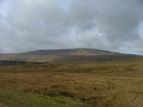
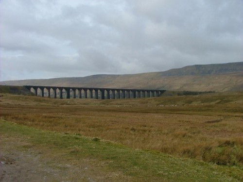
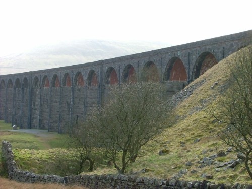
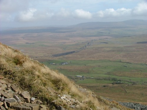
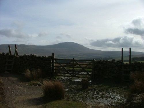
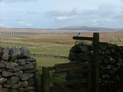
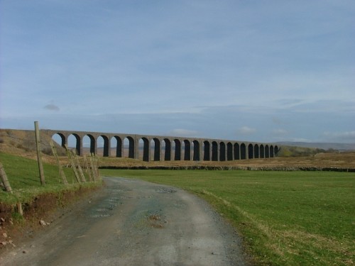
It was a fantastic day, very Spring like when I did the circuit. I parked the car on the verge on the Ingleton, Hawes road just past the junction from Horton in Ribblesdale. The broad spread of Whernside in full view, rising from the valley with the Ribblehead Viaduct to the left.
I togged up with my boots and checked I had my food and drink and all the other essential for the day in the rucksack, locked up the car and headed for the Ribblehead Viaduct. I set off at 11.30am.
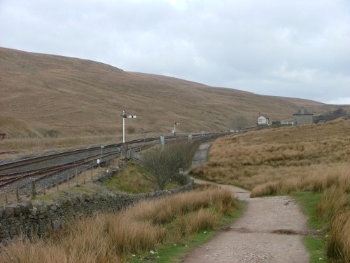
The path from here passes to the right of the viaduct and starts the long climb following the route of the railway line towards Blea Moor.
A glance back at the Viaduct before heading over the first rise and starting the treck towards the far end of the mountain.
The path follows the west coast railway line, you can see the Blea Moor signal box ahead in the distance.
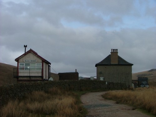
A closer view of the signal box.
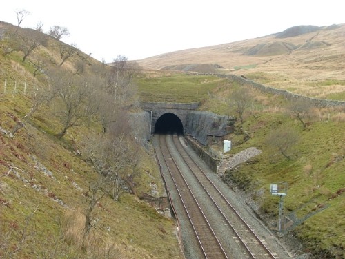
The path starts to steepen slightly now as I continue the climb and cross the railway line by the bridge below Blea Moor Tunnel.
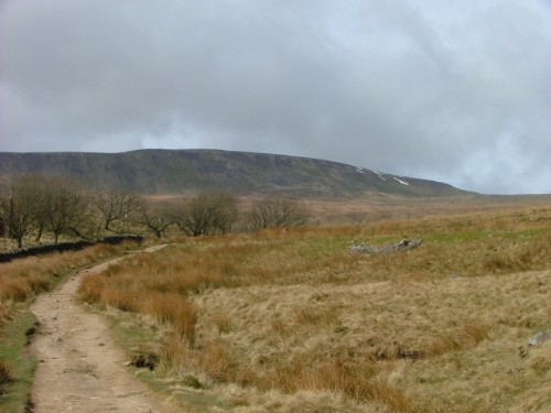
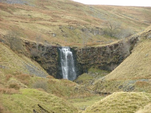
On the other side of the tracks now the route continues on wilder paths and starts to follow a stream to its source on the mountain. Further up the path brings you to Force Gill waterfall.
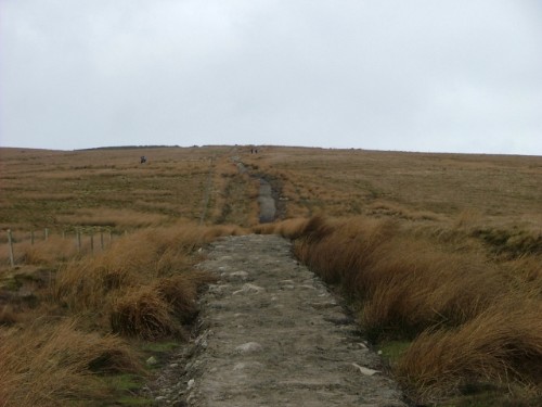
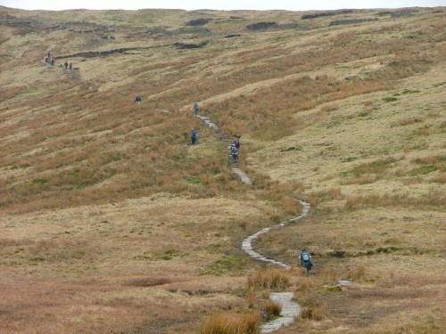
Above Force Gill, the path heads off across the open moorland continuing to climb. The paths have been upgraded since the last time I did this walk which is the best part of 15 years ago. The wettest parts on both Whernside and Penyghent used to have wooden staging for quite extensive sections which was a bit intrusive on the landscape. The replacement paths built from natural packed stone are a lot more in keeping and blend well with the terrain.
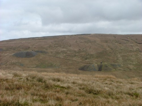
Glancing back from here gives a good view of the air shafts for the Blea Moor Tunnel.
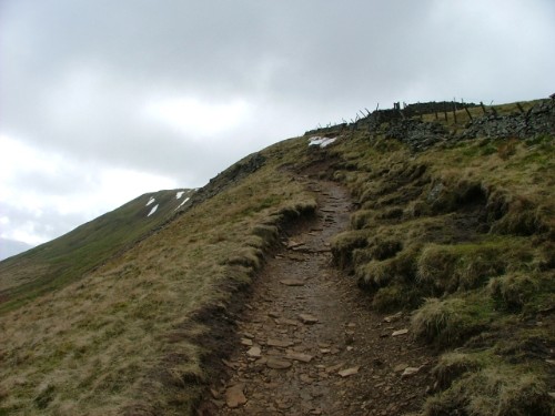
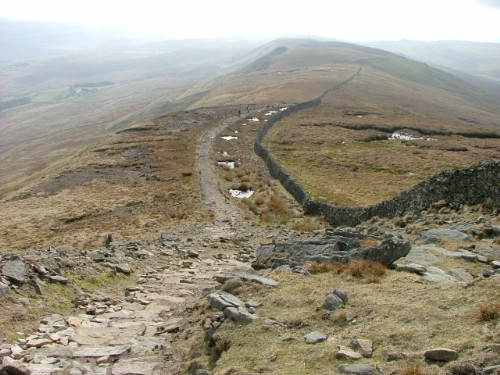
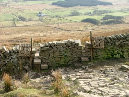
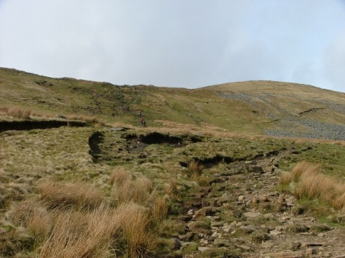
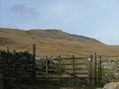
The path at this point heads towards Dentdale, after a steady climb of about 3/4 of a mile I climbed over the style on the left that sets you on course for the long ridged back of Whernside.
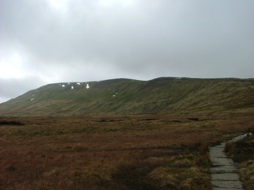
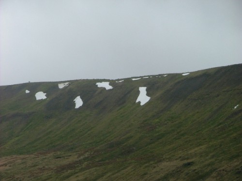
I zoomed in from here to get a better picture of the ridge, snow still clinging to the upper reaches. You can just see other walkers on the ridge heading for the top.
The path starts to climb more steeply now as it winds towards the ridge. The young guy at the bottom of the photo is part of the group at the top of the photo. They were attempting the Three Peaks challenge and at this point were roughly half way round the 23 mile circuit. He was suffering somewhat, (I remember it well from when I completed the circuit). Half a mile earlier when they passed me while I was having a brew they were all together, the signs did not bode well for that lads attempt, I hope he made it though.
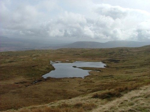
After the climb in the previous photo, my stomach got the better of me and I sat down for a sandwich and another brew overlooking Greensett Tarn. I was glad of the short rest before the final climb to the summit.
The path heads up along the ridge now for the last 3/4 of a mile or so to the summit. There was still snow covering one part of the path, you can just see it in the foreground of the picture. I chatted to another walker as we crossed the snow together, he had been on the summit exactly 4 weeks ago and the drifts were 4ft deep on the ridgeline at that time.
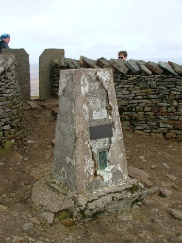
Summit Trig Point at 2415ft. I reached here at 13.40, just over 2 hours, I was quite pleased with that. There was quite a stiff breeze on the top and I settled down behind the wall to eat my other sandwich and have a welcome drink. There were quite a few people out on the fell today. The weather would have a lot to do with that although it was hazy and slightly overcast.
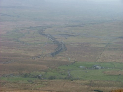
This is the view back down into the valley bottom with the viaduct and railway line snaking its way down to Settle and beyond.
Whenever I climb a hill, I never really like going back down the same way as I went up unless I need to get off a hill fast! After a suitable rest and refreshment I continued on the Three Peaks route and headed off the summit for the "Sharp End" and the descent towards Chapel Le Dale. This route will mean that I will effectively walk the full length of Whernside twice as I have to treck the whole way back to Batty Green.
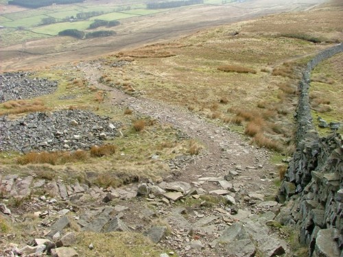
Continuing down along the back of Whernside, the path veers to the left at Low Pike and tips over the edge of the hill for the descent into the valley bottom.
A view along the side of Whernside just as you go over the edge, back towards the viaduct. You can see the steep incline that the path takes. This bit really hammers you on the legs and you have to be carefull not to loose your footing as I managed to do just once on the way down. Fortunately I managed to catch myself and fall backwards into a sitting position rather than go over forwards. The path is about 1 in 3 at the top and a fall here could be really nasty.
About a third of the way down and double styles on the path a bit like a Dual Cariageway!
I took a photo looking back up at this point, quite a few following me down.
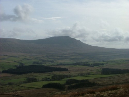
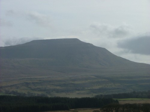
Ingleborough now dominates the view, rising out of the other side of the valley from Chapel Le Dale.
Another view framed between dual ladder styles this time.
Looming larger as the descent gets into the lower reaches.
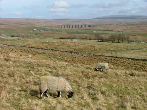
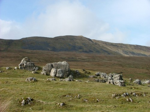
The moorland sheep are oblivious to the magnificent view. The path is now free of the rocks that dominate the upper slopes of all three of the Yorkshire peaks. It's a lot easier going now as the slope eases off into the valley bottom.
Another view back now I have completed the descent. This is from the gate that accesses the bridleway at Kirby Gate.
Turning left through the gate leads onto the bridleway and easy walking on pasture. I leave the Three Peaks route here as I am heading back to Ribblehead. If I was continuing for Ingleborough I could go forward to Philpin or turn right and pass Ellerbeck, Gill Head and into Chapel Le Dale.
A couple of fields and I reach Broadrake, I took this picture postcard view for your delight.
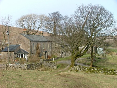
Through the farmyard and another glance to the left back at the mountain. A nice photo with the limestone in the foreground.
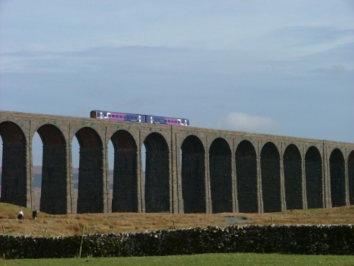
Ribblehead Viaduct features again now as I head back to Batty Green.
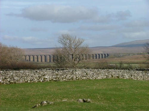
The Ingleborough massif stands like a sentinel in the dale. No wonder it was used as a fortress by the very early Dalesmen.

A view of the viaduct after leaving Gunnerfleet farm.
I managed to catch a train on the viaduct as well
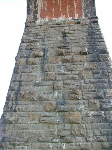
This is a view of one half of Arch No 14 showing the massive stones used in the construction
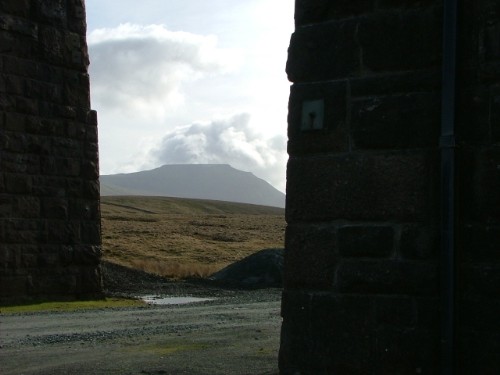
And a final look back at Ingleborough framed through Arch 14.
I stopped off at the tea and butty van at Ribblehead junction on my way back to the car. I got a brew and walked back to where I had parked. It was 15.40 so the walk had taken me just a little over 4 hours. The circular route is about 8 miles. I had a good day, I hope you enjoy the photo's.
Ian |
frankwilk
|
Posted - 17/03/2009 : 07:17
Thank You, what's more to be said wonderful.
Frank Wilkinson Once Navy Always Navy |
Another
Traycle Mine Overseer

6250 Posts

|
|
Posted - 17/03/2009 : 07:24
Panny, thanks for letting us share your walk. Pictures are brilliant. Nolic
" I'm a self made man who worships his creator"  |
Stanley
Local Historian & Old Fart
36804 Posts
|
|
Posted - 17/03/2009 : 07:35
Touch of the Wainwrights.
Stanley Challenger Graham
Barlick View
stanley at barnoldswick.freeserve.co.uk |
wendyf
|
Posted - 17/03/2009 : 07:42
Wonderful, thankyou.
Wendy
|
belle
|
Posted - 17/03/2009 : 09:10
Oh I did enjoy that..used to come down to Leeds to see my daughter on that train....now I know where all the walkers were going. We once drove home following the railway line as best we could...Dentdale inparticular is so beautiful...and I am encouraged by the fact that there is a path and the whole walk is only 8 miles..mmm time to get my walking legs on.. i have been so sedentary since i left cumbria. Partly due to a foot injury which took three years to heal..and still plays up if I do too much..but those pics are luring me out onto the fells...
Life is what you make it |