| Author |
 Topic Topic  |
|
Stanley
Local Historian & Old Fart


36804 Posts

|
|
 Posted -
10/08/2010
:
05:01 Posted -
10/08/2010
:
05:01
|
More pics from the archive. Filling in some of the smaller streets around the town centre. Enjoy...
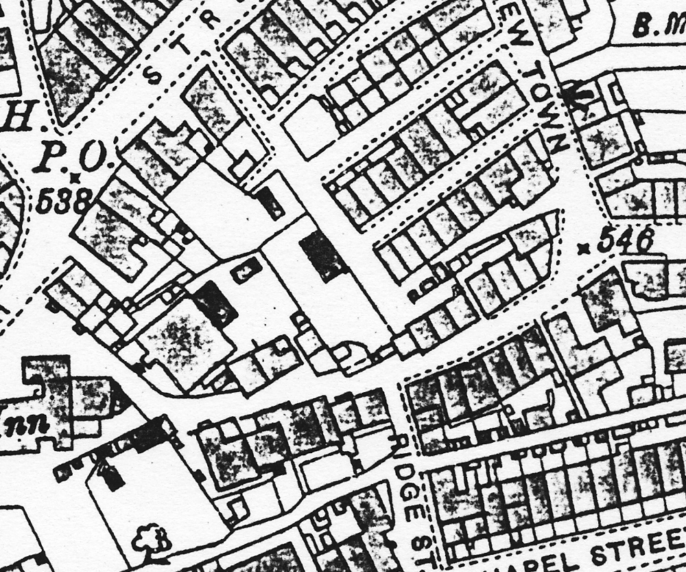
1892 map of King Street.
Stanley Challenger Graham

Barlick View
stanley at barnoldswick.freeserve.co.uk
|
|
| Replies |
| Author |
|
|
gus
|
Posted - 10/08/2010 : 15:46
Excellent photos Stanley, a real treasure.
Gus
http://www.flickr.com/photos/angusbrennan/
 |
Another
Traycle Mine Overseer

6250 Posts

|
|
Posted - 10/08/2010 : 16:59
I support what gus says. Great pictures and thanks for the time and trouble you are taking in posting them. Nolic
" I'm a self made man who worships his creator"  |
Stanley
Local Historian & Old Fart
36804 Posts
|
|
Posted - 10/08/2010 : 17:24
Glad you're Liking them Cathy.Yes, it took a while....
Can't say that I've ever seen the road past the level crossing called anything other than Wellhouse Road. Question is when did Wellhouse Road get its name. All I can say with certainty is that it's named Wellhouse Road on the plans associated with the Bracewell Sale Document of 1887.
Stanley Challenger Graham
Barlick View
stanley at barnoldswick.freeserve.co.uk |
Stanley
Local Historian & Old Fart
36804 Posts
|
|
Posted - 10/08/2010 : 17:28
Thanks Gus and Comrade Nolic. All right, it takes some time but it's worth it I think and Google will soon pick it up. It's made a lot easier by the new Flying Machine and the Ubuntu system, very fast and much easier to search the database, I can access over 3000 pics in one search in well under 20 seconds. Amazing!
Stanley Challenger Graham
Barlick View
stanley at barnoldswick.freeserve.co.uk |
HCF
Regular Member


64 Posts
|
|
Posted - 10/08/2010 : 18:35
quote:
Stanley wrote:
Can't say that I've ever seen the road past the level crossing called anything other than Wellhouse Road. Question is when did Wellhouse Road get its name. All I can say with certainty is that it's named Wellhouse Road on the plans associated with the Bracewell Sale Document of 1887. On the 1892 map posted on 4/5/10 it appears to be marked as Station Rd. That's why I'm puzzled.
|
Stanley
Local Historian & Old Fart
36804 Posts
|
|
Posted - 11/08/2010 : 06:08
All I can say about that is that you are right, it is clearly marked but remember that the OS maps weren't resurveyed to make the 1892 map, it's a revision of earlier maps and the same stretch of road from the railway crossing right down to Wellhouse Mill is clearly marked as Wellhouse Road in the 1887 sale documents which were based on legal documents showing property ownership so regardless of the 1892 OS you can be sure that it was known as Wellhouse Road before 1887. Clear evidence that you can rely on.
Stanley Challenger Graham
Barlick View
stanley at barnoldswick.freeserve.co.uk |
HCF
Regular Member
64 Posts
|
|
Posted - 11/08/2010 : 08:06
Thanks for the clarification.
|
gus
|
Posted - 18/09/2010 : 20:01
 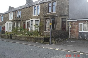
Wellhouse road then and now, the same spot outside the present
firestation
Gus
http://www.flickr.com/photos/angusbrennan/
|
Stanley
Local Historian & Old Fart
36804 Posts
|
|
Posted - 19/09/2010 : 06:41
Nice old pic Gus. Can I please have a higher res file of it? It would make a good cover pic for Vol VII of Stanley's View. I've used old pics on all of them. Have you ever noticed that the two plant-holders in the house next to the old postcard shop are copper timpani?
Stanley Challenger Graham
Barlick View
stanley at barnoldswick.freeserve.co.uk |
thomo
Barlick Born Old Salt


2021 Posts

|
|
Posted - 19/09/2010 : 09:46
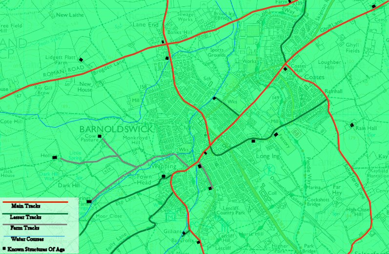
Ref Wellhouse Rd, I have suggested this elsewhere.on the site but drew a blank, Wellhouse farm which later became the Post Office stood roughly where what is now the junction of Church St and Brook St, Given that Wellhouse Farm predated both the Church and the Station is it not possible that the road past there was Wellhouse Rd which continued along what is now Church St and Station Rd to continue as Wellhouse Rd as we know it linking the area around the farm with Coates and Ghyll Church?
thomo |
gus
|
Posted - 19/09/2010 : 10:13
Hope this helps Stanley.
Gus
http://www.flickr.com/photos/angusbrennan/
|
thomo
Barlick Born Old Salt
2021 Posts
|
|
Posted - 19/09/2010 : 16:11
Possibly how it may have been and done without trawling through mountains of documents, therefore probably somewhat inacurate and since posting this pic I have already thought of the sites of other buildings of that era and how they may have affected the pattern of tracks and lanes. For this I appologise now lest the great guns begin to blaze.
thomo |
elise
Regular Member

70 Posts
|
|
Posted - 19/09/2010 : 17:37
Hi, Little Gun here
Would suggest that the red line from The Railway to Coates Hall is incorrect and Skipton Road should be coloured red, the map of 1767 showing the line of intended canal shows it thus.
|
Stanley
Local Historian & Old Fart
36804 Posts
|
|
Posted - 20/09/2010 : 07:23
Peter, I think what is now Church Street was called Westgate at one time.
Gus, sorry, not enough resolution to blow up to 5" wide. Is this the best file you have? If you have a bigger one you could mail it to me? Sorry to be so difficult, good image and new to me.
Stanley Challenger Graham
Barlick View
stanley at barnoldswick.freeserve.co.uk |
thomo
Barlick Born Old Salt
2021 Posts
|
|
Posted - 20/09/2010 : 16:43
Help required please. Late last night I came across a pdf file on line about Barlick with references from Warner, Savage and others, it also had links to this site. I forgot to save it and switched off and cannot now find it again. any assistance would be greatly appreciated.
thomo |