Stanley
Local Historian & Old Fart


36804 Posts

|
|
 Posted - 18/04/2006 : 08:31 Posted - 18/04/2006 : 08:31
Sue sent me this respnse and asked me to post it. I'm having difficulty with re-formatting the illustrations so bear with me, I'll have a word with Sue and we will find a way round it.
The area and homesteads on Widdop Moor
As part of my research into the origins of the Widdup/Widdop families I have carried out some research into the area of, and homesteads on Widdop Moor. An analysis of the IGI, Parish records, and the 1851-1901 censuses has shown that the vast majority of the Widdup families (all spellings) lived in a crescent around Widdop Moor, stretching from Colne, Kildwick, Keighley, Haworth, Bingley Halifax and Heptonstall to Todmorden, Littleborough and Rochdale. In the 1790s the circle was completed as the Rochdale Widdups moved to Salterforth and Barnoldswick, and back into Colne, Nelson and Burnley. Most of those who emigrated to USA, Australia, New Zealand, and Canada can be traced back to specific families on this crescent.
I wished to find out if any of these families actually lived at Widdop/ Widdop village at any time during their history. My research is ongoing, and hopefully sometime in the distant future I will be able to put my findings on the site. For the moment I will keep to the question asked by Stanley. ‘Where was Widdop village’? From what I can see the answer is there was no village as such, just a number of dispersed farms across the moor.
The following is a summary of some research I carried out at Halifax and Preston record offices some months ago.
Halifax
The map of 1834, showing a plan of the Heptonstall Estate in the Parish of Halifax
This identified the collected estate of the house called High Greenwoods including acreage and tenants.
Name of Farm Land size in Acres, Roods, Perch (A R P) Tenant
Bent Head 26-0- 8 John Thomas
Clough House 22-1-26 John Gill
Clough Head 7-8-21 James Horsfall
Harr ( Haw) Royd 31-2-17 William Townsend
High Greenwood and Bent 54-3-2 Abraham Marshall
Coppy and open ground on south side of Coppy 100-2-31 Abraham Marshall and William Townsend.
New High Laithe 18-1-7 William Ashworth
In Hand (Plantation) 47-2-37 High Greenwood Wood
Old High Laithe 19-3-21 James Cockcroft
Widdup Gate (NB Widdup not Widdop) 84-1-5 William Greenwood
King Common 71-2-22 Thomas Greenwood
Reaps 156-3-6 John Stansfield
TOTAL 624-0-6
NB the system of measurement was described in the article The Origins of Measurement on this site

Sketch to show the tenancy and ownership of land and buildings around High Greenwoods
Current map of the area
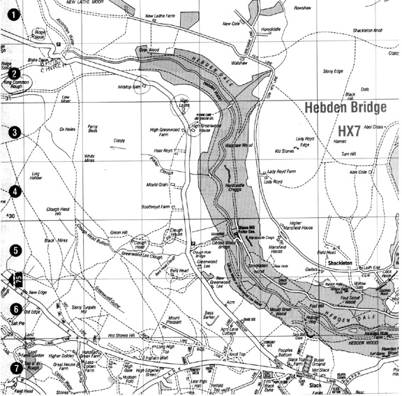
The map of 1888, showing Halifax waterworks extension on Widdop Moor
This map showed
· the proposed extension to the waterworks
· That there was a track and two sets of stepping-stones that ran through the planned site of the reservoir.
· The present day Packhorse Inn was called the Ridge inn
· A number of outlying farms, Ladies Walk, Clough Head, Pasture House, New Laithe Hey that I could not identify on a current map
The map showed plot numbers and positions of buildings
WIDDOP FARM consisted of 26 plots, and 4 farm cottages. In effect this was the position of the reservoir. Also identified was THE OLD HOUSE.
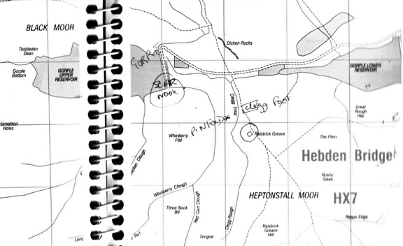
GORPLE consisted of 8 fields and 2 buildings
CLEGG FOOT was one property
PINFOLD one property
RASTRICK GREAVE 1 farm with 9 fields
STANSFIELD MOOR was composed of 12 plots which included Broadholme and Nodale.
Plots Plot numbers for Widdop and comments Plot numbers for Old House and comments
1 10 9
2 11 17
3 12: Farm 18; Widdop farm building
4 13: Farm 19: Widdop farm building
5 14 20
6 15 21
7 16 22
8 23
9 24:Building of OLD HOUSE
10 25
11 26
Plots Plot numbers for Gorple Plot numbers for Raistrick Greave
1 1 39
2 2: Farm 40
3 3 41
4 4: Farm building 42
5 5 43
6 6 44
7 7 45: Farm
8 8 46
9 47
Plots Plot numbers for Broadholme and Nordale
1 27
2 28
3 29: A narrow strip
4 30
5 31: Nodale building
6 32: Nodale building
7 33
8 34
9 35
10 36
11 37
12 38: Broadholme
Current Maps of the area, showing changes that have occurred
1. Widdop

2. Gorple
Halifax and Preston
A series a documents were located relating to land ownership, tenancy and inheritance. Some of these are outlined below
· May 20th 1415: ‘Quitclaim’ of John Draper to his brother Thomas: All property in Wadsworth given to the above Thomas by William Draper his brother. The witnesses were John del Brigg, Richard del Walschawe, Richard Harrison, John del Hakrode, Robert del Widhope (Original document, part of the Sutcliffe Estates Ltd, Hebden Bridge, Family Estate Records)
· July 2nd 1604: A lease of a tenement in Widdop by William Crabtree husbandman in the County of York, from Edward Waterhouse
· Nov 22nd 1604 Grant of annuity by Sir Edward Waterhouse to his brothers Robert and Richard Waterhouse: An annual annuity of £13-6s-8d awarded if they released their interest in Widophead of Heptonstall when they became of age. (NB Edward Waterhouse was of Shibden Hall)
· February 9th 1628: William Crabtree to Mary Mitchell, assignment of a tenement and premises at Widdop, Heptonstall
· July 7th 1634: an agreement between Mitchell Crabtree in the Parish of Burnley, Lancaster and Thomas Cockcroft of Greenwood, the lease of a tenement in Widdop
· 1664 a Will relating to Richard Wadsworth of Warley in the Parish of Halifax:
…bequeath unto the _____ of Richard Wadsworth____ of my late brother William Wadsworth, all affectures, two messuages or tenements lying and being in Widdop within the Lordship or township of Heptonstall in the County of York and all croft lands tenements meadows and pastures…
At Preston records office it is possible to follow documents relating to the transfer of lands and property at Widdop from the 1600s to Aug 5th 1826 when the property was purchased by the Townley Estate from Mitchell, ‘… all lands and farm at Widdop’
Although I scanned through these documents I did not complete a detailed review. The transfer of the land and tenancies appears to have been complex as often when it was inherited it was divided into thirds. The key names were Sheltock, Cockcroft, Crabtree, Horsfall, Mitchell, and Ingham, land passing backwards and forwards between the families. There appear to have been a number of marital connections between the families e.g. in 1631 a letter of Administration of Mary Mitchell was granted to Simeon Crabtree, her brother.
At no time did I find any reference to a village if Widdop. All references were to land/meadows/ tenements or messuages. I concluded therefore that there never has been a village
Stanley Challenger Graham

Barlick View
stanley at barnoldswick.freeserve.co.uk  |
Lifeschool
New Member

1 Posts

|
|
Posted - 09/10/2006 : 12:32
Hi,
Just came across this old topic and thought I'd add the final note. Accorsing to the 1851 map by the O/S, there were many villages in the area taken by the reservoir. These included: Ladies Walk, Worlds End, Wood Plumpton, New Laith Hey, Higher Houses and Lower Houses. There was no 'widdop village' as such. At the center if the area way a huge bog with the river running around it.
In case you are interested, widdop is the crater of a vast volcano which existed hundreds of millions of years ago. It is in the center of the four higher peaks of Lad Law hill, Delf Hill, Hambledon and High Rakes to the East. It is also the junction of two important Ley-lines. The first runs on a line from Gisburn in the north, through Hebden Bridge in the south east. The second line runs north east from the Ramsbottom Monument and Waterfoot. I guess you could say, widdop is the center of the world up there!
Daniel Waddington |