| Author |
 Topic Topic  |
|
Doc
Keeper of the Scrolls


2010 Posts

|
|
 Posted -
14/06/2005
:
19:03 Posted -
14/06/2005
:
19:03
|
This history describes the field boundaries and enclosures built by farmers, husbandmen and labourers, which are such an important feature of the countryside they traverse, and which remain mostly in use today. It does not include the dry stone buildings and fortifications of earlier times, such as the Iron Age brochs of Scotland or the village of Skara Brae in the Orkneys, many of which exhibit advanced craftsmanship in dry stonework.
The enclosing of the rocky uplands of Britain began well back in prehistory, during the period when a nomadic pastoral and hunting life gradually gave way to settled farming. This left a permanent if faint mark on the land in the form of stone circles and surrounding irregular patchwork of ditches and dykes, which is the trademark of the 'Celtic' field system. These early settlements were concentrated on the drier terraces and hillsides where woods and scrublands were most easily cleared. They now remain, often far above the present limits of cultivation, as evidence of a milder climate. In Ireland the earliest traces of walled fields have been discovered incorporated into megalithic tombs of late Neolithic age. Here the pattern of small, apparently random-shaped fields may still be found around the scattered farmsteads which replaced the old 'clachans' or tribal hamlets.
In Britain, the remains of settlements around the South Western moors, in the Lake District and on the limestone and gritstone terraces of the western Pennines are usually assigned to the Romano-British period, although occasional findings have been dated as far back as 2000 BC. Certainly it was around the time of the Roman invasions when fairly cohesive tribal federations developed, capable of erecting extensive fortifications and defensive earthworks.
The next main period of wall building began in the early Middle Ages and continued, slowly and with many changes of pace depending on the economic conditions of the time, into the post-medieval period. It has been traced most thoroughly in Yorkshire where it is associated with the Anglo-Saxon and Scandinavian settlements of the 6th century AD onward (Raistrick, 1966). It was then that the open field system so characteristic of medieval English agriculture really developed. Typically, settlements divided their holdings into three sections. On the fertile, flat and seasonally flooded bottomlands the 'leys' or 'ings' were located, divided from the drier ground by a permanent ditch and fence, hedge or dry stone wall. The two or three common fields were similarly fenced off from each other, and from the third section, which was the common pasture
>or waste which extended to the borders of the next settlement. There were no permanent divisions within the water meadows or the common field. Where medieval walls remain, they are of huge clearance boulders with little coursing of the stones, and no throughs or topstones, but with some batter. They follow fairly irregular alignments, in response to immovable obstacles or the waller's whim.
Although open-field walls can still be traced in some of the Yorkshire Dales villages, notably Linton in Wharfedale, the total impact of these enclosures was limited. Most land remained as waste, outside the bounds, although from the 12th century onward grazing disputes led in a few cases to the erection of walls between large holdings. These moorland walls or ditches are seldom traceable today, but they remain among the earliest fences for which written documents are available (Chapter 1).
Meanwhile in the 'Celtic fringe', the older infield-outfield system persisted, even where the earlier settlements were abandoned. In the granite areas of Cornwall and Devon, in parts of Wales and Scotland, and through much of Ireland, the story is one of continued nibbling away at the open land. Tiny garden-like plots fenced by massive clearance walls surrounded each farmstead, but these islands of cultivation remained virtually swamped in the vast expanse of open moor.
The next definable walling period, which particularly affected the Pennine region, started in the 14th and 15th centuries, and continued until the 18th. It was at its height in the Elizabethan period when cottagers and householders for the first time were legally permitted to enclose small 'crofts' or private holdings. The fertility of arable land was nearly exhausted by this period. To revitalize the land, it was necessary for individual householders to use their own stock to manure and improve their holdings. Crofts were small, about half an acre (0.2 hectare) on average, with four or five scattered crofts held by each house. Crofts were walled by the individuals concerned using stone quarried or cleared from the common waste. Although the walls were still squat and poorly coursed, their lines were rather more regular than the older piecemeal enclosures. By the 16th century, attempts were being made to breed improved types of sheep for their wool, and parts of the outlying wastes were enclosed to make this work easier. Enclosures in the north were restricted to the vicinity of the villages, while more extensive fencing took place in the south and Midlands. In the Pennines this period brought the completion of that 'maze of small enclosures, crofts and tiny fields, with scarcely a straight wall among them' which still surrounds many Dales villages (Raistrick, 1966).
The population continued to grow during the 17th and 18th centuries, putting pressure on the old open-field system. In the Pennines, this early industrial period saw the enclosing of 'intakes', which were rectangular fields of 1-3 acres (0.4-1.2 hectares), located beyond the old common fields. The moorland soil was unsuitable for crops, but could be limed and drained to support sheep. These intakes provided the mining and textile labourers who farmed them with a source of protein, as well as with the outdoor work which their employers considered beneficial.
This period also saw far more extensive enclosures to form the principal pastures of the community, often several hundred acres in extent, and divided adjoining townships from one another. They were made by common consent, and involved all the shareholders in the construction and, frequently, the repair of the walls. Usually a shepherd was paid to tend the pastures, and sometimes he had the duty of repairing walls and gates. Outside wallers or masons were seldom required, either for building or maintenance.
About 1780, the situation changed drastically. From this time, enclosures were promoted by large landowners or one or two private individuals in each area for their own benefit. These people had the means and influence to engineer private Acts of Parliament which effectively stripped the smaller farmers of their common rights. Each Act appointed commissioners to survey the area in question, and to allot portions to every claimant, along with proportional responsibility for fencing the holdings. Since the set limit for walling the bounds was only a year or two, the specifications were very exacting and the length required was often many miles, the commissioners had to hire wallers or men free from the land to do the work. Only the wealthiest parties could pay for this labour; the others had to forfeit their shares to the commissioners. As Raistrick (1966) concludes:
'The enclosures were a tragedy for the small man; he lost his right of pasturage on the common, lost his bit of land, and was compelled to become a wage labourer in a time of falling wages and rising cost of living. It secured the enslavement of the labouring classes.'
In 1801 the situation was further rationalised by a general Act of Parliament, and by 1820 most of the work was done. The old common field had been subdivided into small straight-walled rectangular plots. In the Pennines these enclosure walls are visually unmistakable, with their precisely placed throughs and topstones, uniform batter and unvarying height. These walls were planned by city surveyors and built by professionals, who worked in gangs all through the clement months to finish the job.
Taking England as a whole, much land was in its modern form even before the Enclosure Acts. In the Midlands, perhaps the heart of the open-field system, at least 30% of the land was enclosed by 1700. In many counties, including Kent, Sussex, Devon, Herefordshire, Worcestershire, Cheshire, Lancashire, Staffordshire, Northumberland, Durham, Suffolk and Essex the open-field system had never had a strong hold, and piecemeal enclosure had taken place more or less continuously from the 12th century onwards.
In the south west of England and much of Wales, the old Celtic field system had evolved gradually into one of separate farmsteads surrounded by small fields, with large areas remaining as common moorland. In Wales, walling remained a matter for the small farmer, even after he became tenant to an absentee landlord. A Royal Commission report of 1894 states that 'the stone walls in the neighbourhood were generally built by the tenant, except near the mountains, where sometimes the walls were long ones, and these were built by the landlord.' The Commission noted many complaints from tenants that landlords 'exhausted' the compensation for their work over a period of only fourteen or fifteen years, whereas the walls were as good as new for twenty or thirty years or more.
According to Rainsford-Hannay (1972), enclosures started in Scotland with an Enclosure Act of 1710, relating to some land in west Kircudbrightshire. Pieces of land were leased free to people who would move to them in spring, set up huts reminiscent of the Highlanders' sheilings, work their plots and in return build enclosure walls. Within a year or two many miles of dykes had been raised, greatly increasing the value of the land. This example was quickly followed, but not without opposition from bands of people who tried to break down the walls and injure the enclosed animals. The ringleaders were executed, and thereafter the enclosures proceeded virtually unhindered.
Many Scottish dykes were built to standard specifications, the best and tallest being the march dykes which bounded the great estates. In some places, special problems resulted in unusual walls, such as Monymusk clearance or 'consumption' dykes northwest of Aberdeen. Rainsford-Hannay (1972) quotes from contracts of 1736 and 1741 in which the tenant was required to wall a certain area to a height of one ell, or 3'1" (940mm), using stones 'taken from within, as long as there are any, both great and small' and 'not to leave a stone in the enclosure, which three men cannot roll or four men carry in a hand barrow'. The first contract specified a coping of 'faile' or peat sods, but the later contract omitted this, probably because it robbed the land of important topsoil. Instead the tenant was paid to bring the wall up to a height of 4'7" (1.4m) as and when he wished, using stones which arose after ploughing. The biggest consumption dyke is Kingswell West Dyke (Chapter 11).
Lake District enclosures were on the whole rather late. Until the Union of 1603, raids across the border from Scotland kept the area so insecure that the land continued to be communally farmed, which made it easier for some men to leave the land at short notice for temporary military service. After the cessation of border troubles many of the common township fields were enclosed and improved by private agreement, but farming remained generally backward compared to elsewhere in the country. Most Lakeland walls were built after the Parliamentary Enclosure Act of 1801.
>Most Irish walls are also fairly recent. >From the mid-18th century enclosure was advocated by land reformers, but there was much local resistance to permanent walls. Instead, one-year sod barriers were constructed, which were then thrown down after the harvest so they could replenish the soil. This practice continued into the 18th century in many areas. The ancient megaliths of Ireland have remained mainly untouched, even during periods of walling activity, as there was a strong superstition against the splitting of large stones.
The history of dry stone enclosure walls does not quite end with the 19th century, even though little land remained to be subdivided. Mining activities brought temporary bursts of walling in certain areas, such as some of the Yorkshire Dales. In the 20th century, road widening and building has brought the need for construction of many miles of walls. During the 1930s, rebuilding of roadside walls in the West Riding of Yorkshire was used to ease local unemployment. In recent times, the National Parks and other authorities concerned with the conservation of the countryside have been active in promoting dry stone walling through grants and other schemes (chapter 2). From there being very few full-time wallers working during the mid part of the 20th century, numbers are now rising again, as the importance of conserving the walled landscape has become apparent. As detailed in chapter 2, many walls are in a poor condition, and it would need an investment similar to that of the enclosure era to rebuild them. The walled landscape of upland Britain is a monument to centuries of patient labour, and it is too important to be left to decay.
|
|
| Author |
Replies |
|
Ringo
Site Administrator

3793 Posts
|
|
Posted - 14/06/2005 : 23:06
 I was expecting a history of the ice cream manufacturer.... I was expecting a history of the ice cream manufacturer....
 |
Doc
Keeper of the Scrolls
2010 Posts
|
|
Posted - 14/06/2005 : 23:19
"Sausages"
TTFN - Doc

Due to the current economic climate, the light at the end of the tunnel has now been switched off.
Click here to make a donation and help support this site and keep it advert free 
|
Callunna
Revolving Grey Blob


3044 Posts
|
|
Posted - 15/06/2005 : 08:51
Thanks for this, Doc.
It will help enormously when I go on my dry stone walling course soon.
=================== www.sheldrickrose.co.ukwww.bernulf.co.ukwww.bernulfsplace.co.uk |
Stanley
Local Historian & Old Fart

36804 Posts

|
|
Posted - 15/06/2005 : 11:14
Heather, one aspect of walling was always 'gap-walling' which was done by casual labour. A man would bbe set on by a landowner to wall up the gaps in his walls and was paid by the yard. An old waller once told me that his best friend was his hammer, when he'd walled a gap up he marked the stones in the wall on either side of the gap with the hammer and charged for an extra yard or two.
Stanley Challenger Graham

Barlick View
stanley at barnoldswick.freeserve.co.uk |
BenR
Regular Member


200 Posts
|
|
Posted - 27/10/2007 : 21:33
Stanley, I guess your PC alerts you to new posts....?
There's a fascinating bit of walling between Hebden Bridge and Stoodley PIke. South of the town just up the hillside from a settlement called Horsehold (an old packhorse royd, I'm sure) is an area of several acres where at each junction of the walls enclosing some small fields, the waller has built a little "diamond" instead of just bringing the walls together in a conventional cross. The diamonds are now filled with mature trees but every time I cycle or walk past there I wonder why they did it. You can even see them on the 1:25,000 OS map. Any ideas?
|
Stanley
Local Historian & Old Fart
36804 Posts
|
|
Posted - 28/10/2007 : 06:21
Haven't the faintest Ben. Sounds to me like a bit of fancy on the part of the landowner. I doubt if the waller would have done it off his own bat. Never seen amything like it. As for alerts, everyone uses the site in a different way. I always got to active topics and alter it to one day ago. That way I miss nothing. I read all the topics of course mainly for a check as to what is going on in case anything needs a touch of the steering wheel..... That's when I really get into trouble......
Stanley Challenger Graham
Barlick View
stanley at barnoldswick.freeserve.co.uk |
BenR
Regular Member
200 Posts
|
|
Posted - 28/10/2007 : 06:54
Another early riser, eh?
I came back to this post this morning to add the grid ref SD986262, you can see the walls if you cut & paste this into the search box here: http://www.ordnancesurvey.co.uk/oswebsite/getamap/
I guess these are the straight walled rectangular enclosures from 1801 to 1820, which you mention in the resume above.
One other point - above Lumbutts, a couple of miles SW of Hebden Bridge, are some fine examples of Pennine packhorse trails. This is a subject, which fascinates me. I got so interested in it that I even had an article published in a mountain bike magazine, in which I described a ride along one of these amazing ways of close packed stones. Lumbutts is also the home of Sue Hogg, of the South Pennines Packhorse Trails Trust, who has spent hours researching old trails and then going to court to get them reinstated as bridleways for the benefit of horse riders. It was she who put me onto the Magna Via, the main trunk of the packhorse trails, now a scheduled ancient monument, which climbs out of Halifax. Did you know for example that a hollow way is the V shaped groove worn in the ground by the passing of thousands of pack horses, and that Holloway in North London is so-called because it was the main route for all the freight into and out of London, before the canals, railways or roads?
Edited by - BenR on 28 October 2007 07:01:52
|
Stanley
Local Historian & Old Fart
36804 Posts
|
|
Posted - 29/10/2007 : 06:28
There is quite a bit on the site about packhorses. I have an idea that the title of the Stanley's View articles is 'early transport'.
Stanley Challenger Graham
Barlick View
stanley at barnoldswick.freeserve.co.uk |
Stanley
Local Historian & Old Fart
36804 Posts
|
|
Posted - 29/10/2007 : 06:37
Here's the first article, the others are called 'Transport in Barlick'. Go to them via forum search.
BADGERS, BROGGERS, GALLS AND JAGGERS.
I couldn’t resist the title and I’ll put you out of your misery straight away if I have confused you. A ‘badger’ is an ancient name for a tradesman who was licensed to deal in corn. A ‘brogger’ was similar but dealing in wool, yarn or cloth. A ‘gall’ is short for a Galloway, a small hardy breed of horse much favoured by packhorse proprietors and ‘jagger’ is the same but a small bred German cavalry horse, the name comes from the German word jaeger or hunter.
I was asked a question the other day about packhorses and realised how little I knew about the trade so I thought I’d do a bit of digging. The results have been enlightening so I thought I’d have another look at transport over the last 1000 years in Barlick. You may have to bear with me for a week or two because it’s a big story.
There has never been a time in human history when transport was not important. Even our nomadic ancestors 10,000 years ago had to carry their possessions when they moved from one hunting ground to another. For thousands of years this was the norm, if you wanted to shift something you put it on your back and walked. We still do it today when we carry the shopping home from the supermarket.
As recently as the late 19th century weavers were walking with packs on their backs to where they obtained their yarn and sold their cloth. There is a reference in ‘The Rambler’ of 1906 where Mr Stephen Clarke tells of a conversation with an old handloom weaver in Blacko who told him that he used to carry his finished pieces of cloth eight miles to Clitheroe and he knew two weavers in Grindleton who regularly walked 10 miles from there to Barnoldswick for their warp and weft, almost certainly dealing with a branch of the Bracewell family. The packs they carried would be about 40lbs weight (18kg).
We should ask ourselves a question here. What if the weight was more than a man could carry or was further than a day’s march? The modern answer would be some form of wheeled transport and the assumption might be that this would be the case say 500 years ago but if we are thinking about Barlick, or anywhere north of a line from Bristol to the wash in England we would almost certainly be wrong. Graham, in his book ‘The Social Life of Scotland in the eighteenth century’ relates how when a load of coals was carried by cart from East Kilbride to Cambuslang in 1723 ‘crowds of people went out to see the wonderful machine. They looked with surprise and returned with astonishment’. Admittedly the further North you went the more backward the technology but as late as 1607 the Parish of Weybridge in Surrey asked to be excused from supplying transport for the Queen’s journey to Oatlands on the grounds that they had ‘but one cart in the Parish’. A traveller in Northumberland reported in 1749 that there wasn’t a cart in the county.
We might be forgiven for wondering why this was the case. The answer lies in the absence of roads as we know them in the North of England. There was no road between Liverpool and Manchester until 1760. In 1718, in Derbyshire, the justices decided to build a ‘horse bridge’ at the Alport ford because of the ‘great drifts of London Carrier’s horses, malt horses and other daily traffic and carriers.’ No mention at all of wheeled traffic on one of the busiest routes in the kingdom, what is now the A6. The pressure of commerce demanded better transport and in 1663 the first turnpike trust from London to York on the Great North Road was established. There was a great expansion in the 1750s-70s, thousands of trusts and companies were established by Acts of Parliament with rights to collect tolls in return for providing and maintaining roads. A General Turnpike Act was passed in 1773 to speed up the process of setting up such arrangements.
This doesn’t mean that there were no wheeled vehicles at all, simply that the crude carts that existed were only used locally. So, in terms of Barlick we’re fairly safe in assuming that it wasn’t until early in the 18th century that local turnpikes made carriage of goods between the major towns possible. Before this everything had to be carried by packhorse and passengers were accommodated on ‘pad nags’, a packhorse with a ‘pad’ or crude saddle instead of the usual packs.
Two facts became clear to me when I started to look into this subject. The first is that I had always had this romantic view of man and a lad with a train of a few packhorses plodding along a salter’s way, perhaps even over the Salter’s Ford’ (Salterforth) on a summer’s day. In reality it seems that there was much more traffic than I had imagined, even on a local basis. The local tracks would have been busy and this raises the question of how many horses were employed in the trade, where were they based and how much traffic there was.
The second fact that emerged was the range of goods that needed to be transported. Even in a self-sufficient economy such as Barlick in the 16th century there were certain goods that had to be brought in. Corn, coal, lime, salt and bar iron spring to mind. What really surprised me was the fact that there were well established trades in perishable goods. I have no direct evidence for Barlick but I’ve found references to fresh salmon being carried from Carlisle to London and even more surprising, live carp! The latter could be kept alive for many days if packed in a hamper of wet straw and so were perfectly fresh on arrival. Mind you, I’m not suggesting that anyone in Barlick could afford fresh salmon at four shillings a pound in 1724 but it is as well to take note that such things were possible.
Right, we’ve set the scene. Next week I’ll look at the Barlick traffic in more detail.
SCG/19 September 2005
1034 words.
Stanley Challenger Graham
Barlick View
stanley at barnoldswick.freeserve.co.uk |
BenR
Regular Member
200 Posts
|
|
Posted - 29/10/2007 : 18:36
Found and read all with fascination, thanks. This thread has drifted from walling to packhorses, it's a bit like the US military's "mission creep". Would it be worth having a packhorse trails section?
I'm not "horsey" but I would LOVE to see a packhorse train in action. These were the early equivalent of today's white van; they charged around the countryside at a fair old lick, stopping for nobody. The only place I know, which has a packhorse is Beamish near Consett. There must be enough galls around (now known as fell ponies or dale ponies depending on which side of the Pennines) to put together a good-sized train. Trouble is, I guess the ponies were long accustomed to travelling together because there was a hierarchy and a leading mare. It would probably not be easy to re-create the order and speed of an experienced train in just a weekend no matter how enthusiastic the human participants!
Edited by - BenR on 29 October 2007 18:40:00
|
Stanley
Local Historian & Old Fart
36804 Posts
|
|
Posted - 30/10/2007 : 06:39
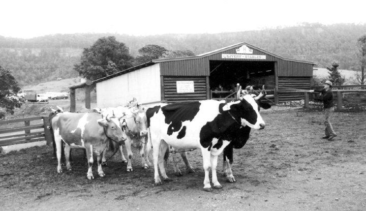
I saw this bullock team in NSW 20 years ago. Ten bullocks and all controlled with the whip. Very impressive and this would have been a common site here 300 years ago but perhaps not as many in a team. I talked to the bloke and he said that they used to use any bullock they could lay their hands on, no special breed. His family had been in the game for years.
Stanley Challenger Graham
Barlick View
stanley at barnoldswick.freeserve.co.uk |
|
|